

Places of memory of the resistant Vercors
Typology, actors and spatial distribution
The definitions of Pierre Nora and Gérard Wajcman served as a framework for the study of the Groupe Vercors Résistant (GVR) because they apply to the Vercors. These places present a heterogeneity that bears witness to memories: individual or collective plaques, steles, monuments, memorials, museums and necropolises. The massif is thus studded with different markers, most often linked to the battles that took place in a given place.
Authors: Julien Guillon and Guy Giraud
Sources :
Collective (under the direction of Pierre Nora), Les lieux de mémoire, Paris, Gallimard, 1997.
Gérard Wajcman, L’objet du siècle, Paris, Verdier, 1998.
Diversity of material representations
These places of memory are materialised in various forms:
- a simple wooden cross, planted on the ground, showing the identity and date of death of the combatant or civilian;
- a concrete base surmounted by a truncated column indicating a date and the name of a missing person
- a plaque indicating the name(s) of the martyrs, civilians or maquisards, and, sometimes, the date and circumstances of the death;
- a communal monument which brings together, inscribed in stone, the dead of the great wars, those of the Resistance as well as those of the deportation, and, in certain cases, those of executed persons;
- a necropolis where the graves of civilians and combatants killed or massacred during certain battles are gathered (Saint-Nizier-du-Moucherotte, Vassieux-en-Vercors);
- a monument (martyrology of Vassieux-en-Vercors), an artistic representation entrusted to a sculptor or a painter;
- a memorial ;
- a museum.
Author: Guy Giraud
Sources:
Collective (under the direction of Pierre Nora), Les lieux de mémoire, Paris, Gallimard, 1997.
Olivier Vallade, Major Fouyat, Des combats au souvenir. Places of Resistance and Memory. Isère et Vercors, Grenoble, PUG/MRDI, 1997.
Annette Wieviorka, Serge Barcellini, Passant, souviens-toi ! Les lieux du souvenir de la Seconde Guerre mondiale en France, Paris, Plon, 1995.
Inventory of places of remembrance by Guy Giraud.
The actors of remembrance
The census and the marking of graves began very quickly, thanks to the action of the National Association of Pioneers and Volunteer Combatants of the Vercors (ANPCVV) or to private initiatives (J. La Picirella – museum of the Resistance of Vassieux-en-Vercors). The ANPCVV is notably the initiator of the necropolis of Vassieux-en-Vercors (Drôme), erected in 1948 to receive the bodies of 187 combatants and civilians killed in the German attacks of the Vercors maquis. It also contains all the commemorative plaques placed by the former Resistance fighters’ associations. In 1981, it was enriched with a Remembrance Room. In Isère, the ANPCVV erected the Saint-Nizier-du-Moucherotte necropolis in 1947.
From the 1990s onwards, these places were gradually considered as a real heritage. They have therefore been progressively institutionalised, modifying their consideration and management. The State and local authorities (Region, departments, municipalities) now ensure, in partnership with traditional memory associations, including the ANPCVV, the development of these places of memory:
In 1994, the Resistance Memorial located at the La Chau Pass in Vassieux-en-Vercors (Drôme) was inaugurated; it is managed by the Vercors Regional Natural Park (PNRV), for which the Region, among others, provides the funding.
In 1999, the Department of the Drôme took over the museum created by Joseph La Picirella. It was completely renovated in 2010.
In 2014, the two necropolises built and managed by the ANPCVV became State property. The ONACVG is responsible for their maintenance, management and enhancement. An agreement regulates the relationships between the various players: commune/departmental museum of the Resistance/Memorial/ANPCVV.
Authors: Guy Giraud and Julien Guillon
Les définitions de Pierre Nora et de Gérard Wajcman ont servi de cadre d’étude au Groupe Vercors Résistant (GVR) car elles s’appliquent au Vercors. Ces lieux présentent une hétérogénéité qui témoigne des mémoires : plaques individuelles ou collectives, stèles, monuments, mémorial, musée et nécropoles. Le massif est ainsi constellé de différents marqueurs, liés, le plus souvent, aux combats qui se sont déroulés à un endroit donné.
Auteurs : Julien Guillon et Guy Giraud
Sources :
Collectif (sous la direction de Pierre Nora), Les lieux de mémoire, Paris, Gallimard, 1997.
Gérard Wajcman, L’objet du siècle, Paris, Verdier, 1998.
Places of memory
These places of remembrance correspond to the major events that took place on the massif and its surroundings between 1940 and 1944. The “Vercors” is a generic name that encompasses a multitude of landscapes made up of “small countries”. For Jules Blache, before the war, the massif was made up of “[…] two domains that turned their backs on each other and had no common name [1] “. 1] Straddling the Drôme and Isère departments, it was however this area that was chosen by the movements (Franc-Tireur, Combat) for the delimitation of the Resistance sectors. For this study, five main areas were therefore selected to facilitate the reading and classification of the data:
- The “Quatre-Montagnes”/Coulmes area
- Historical Vercors
- Royans / Gervanne
- Diois
- Trièves / eastern cliffs and Drac valley.
Authors: Guy Giraud and Julien Guillon
Source :
1] Jules Blache, Les massifs de la Grande Chartreuse et du Vercors, Didier et Richard, Grenoble, 1931, republished by Laffitte reprints, Marseille, 1978.
The Pays des Quatre-Montagnes and the Coulmes
This entity constitutes the northern part of the massif, in Isère. It is characterised by synclines (the valleys of Lans-en-Vercors/Villard-de-Lans and Autrans-Méaudre-en-Vercors), large inhabited valleys situated at an altitude of around 1,000 metres. On its margins, the communes of Malleval-en-Vercors, to the north, and Corrençon-en-Vercors, to the south, mark the limits. The Bourne river, for its part, delimits the Vercors massif between its northern and southern parts. It is traditionally oriented towards Grenoble or the Bas-Grésivaudan because access was easy.
Before the war, a Grenoble/Villard-de-Lans tramway line provided connections. Finally, shuttles were provided by the Huillier transport company, notably in 1940-1944. The duality of the foothills (city-boroughs – valleys-mountains) marks the places of remembrance drawing common paths of resistance.
After the German attacks of 13 and 15 June on Saint-Nizier, a “no man’s land” was established in the Lans valley. The 6th BCA withdrew to the western foothills of the Plaine, from Croix-Perrin to Corrençon, with the Germans only carrying out reconnaissance as far as Villard-de-Lans, in particular to check on the teaching staff and pupils of the Cyprian-Norwid Polish high school.
On 21 July, the Germans launched their assault on the Vercors. A group of the German 157th DR set off from Saint-Nizier towards the Croix-Perrin pass to reach the Autrans-Méaudre valley, despite the resistance of the 6th BCA, commanded by Costa de Beauregard (Durieu). The group continued its progression towards Corrençon-en-Vercors and Valchevrière with the aim of joining the Luftwaffe paratroopers airborne by gliders at Vassieux-en-Vercors.
Three periods summarise the history attached to the places of memory in the Quatre-Montagnes sector:
- March 1944: a clash with a German patrol occurs at Saint-Nizier-du-Moucherotte,
- June 1944: the fighting of 13 and 15 June 1944 started at Saint-Nizier-du-Moucherotte,
- July and August 1944: German attack, followed by an extensive sweep of the massif.
The war memorials of the communes gather the names of the Resistance fighters and those of the great wars of the 20th century.
Author: Guy Giraud
Saint-Nizier-du-Moucherotte
On 13 June 1944, the Germans launched a battalion from Grenoble to carry out an initial reconnaissance of the Maquis position; the Resistance fighters managed to repel them.
The battle resulted in twelve killed and six wounded on the Maquis side, one killed and five wounded on the German side.
On 14 June, German reinforcements arrived and opened fire, but caused no damage to the defences.
In the early hours of the 15th, the German troops renewed their attack with reinforced means and artillery support. This time, barely 600 Resistance fighters were fighting against 2,000 Germans and militiamen. Despite the fierce fight of the maquisards, who were too lightly armed, the attackers advanced everywhere. At around 10 a.m., François Huet ordered his men to withdraw towards Croix-Perrin, Corrençon and Valchevrière.
In total, the fighting at Saint-Nizier cost the lives of twenty-one Resistance fighters, nine civilians from Saint-Nizier and thirteen German soldiers.
In memory of these battles, a necropolis was erected at Saint-Nizier-du-Moucherotte, inaugurated in 1947, under the aegis of the ANPCVV.
Author: Guy Giraud
Lans – Villard-de-Lans – Valchevrière – Corrençon
After the German attacks of 13 and 15 June on Saint-Nizier, a “no man’s land” was established in the Lans valley. The 6th BCA withdrew to the western foothills of the Plaine, from Croix-Perrin to Corrençon. The Germans only carried out reconnaissance as far as Villard-de-Lans, in particular to check on the teaching staff and pupils of the Cyprian-Norwid Polish high school.
On 21 July, the Germans launched their assault on the Vercors. A group of the German 157th DR set off from Saint-Nizier towards the Croix-Perrin pass to reach the Autrans-Méaudre valley. It continued its progression towards Corrençon-en-Vercors and the hamlet of Valchevrière with the aim of joining the Luftwaffe paratroopers airborne by gliders at Vassieux-en-Vercors. The road linking Villard-de-Lans to Valchevrière is a compulsory passage, difficult to cross, and therefore in theory easy to defend, especially as the access bridge to the Bourne Gorges, the Goule-Noire bridge, had been destroyed by the Resistance. The fighting at Belvedere de Valchevrière (Les combats du Belvédère de Valchevrière) took place on 21, 22 and 23 July 1944.
Jacques Douillet, born in 1893 and ordained a priest in 1922, decided to erect a fourteen-station Way of the Cross along the road to preserve the memory of the heroes and martyrs, both civilians and combatants, of the Vercors. This monumental ensemble was inaugurated on 12 September 1948 by Monseigneur Caillot, Bishop of Grenoble, in the presence of a huge crowd.
Author: Guy Giraud
Source:
From information provided by the Maison du Patrimoine de Villard-de-Lans.
Autrans – Méaudre
On 21 July 1944, the Germans launched their assault on the Vercors. A group of the German 157th DR set off from Saint-Nizier towards the Croix-Perrin pass to reach the Autrans-Méaudre valley. The group continued its progression towards Corrençon-en-Vercors and Valchevrière with the aim of joining the Luftwaffe paratroopers airborne in Vassieux-en-Vercors.
Authors : Guy Giraud
Malleval
A commune located in the Coulmes, a small country of the Quatre-Montagnes, Malleval had 41 inhabitants in 1936.
In 1943, several maquis (plusieurs maquis) set up shop without depending on the Vercors organisation. This was the case of the former 6th BCA, commanded by Lieutenant Eysseric (Gustave); a group of Francs-Tireurs et Partisans (FTP) in the hamlet known as “des Belles”; and the small maquis of Abbé Grouès (abbé Pierre), who had managed to leave the area before the attack of 29 January 1944. Acting on the tip-off of a French agent, the Germans sealed off all the exits from the Malleval valley at night. At daybreak, the frontal attack was launched from Cognin-les-Gorges up the gorges of the Nant, towards the village and the hamlet of “des Belles”. Maquis and civilians were executed or deported.
On 29 July 1944, after the dispersal order, 7 Maquis were killed during their attempt to escape from the Vercors.
The commune of Malleval was renamed Malleval-en-Vercors on 12 September 2005.
Author: Guy Giraud
The historical Vercors
The historical Vercors constitutes the southern part of the massif, in the Drôme department. The communes of Vassieux-en-Vercors, La-Chapelle-en-Vercors, Saint-Agnan-en-Vercors, Saint-Martin-en-Vercors and Saint-Julien-en-Vercors mark the human occupation.
In the foothills, the Diois (Die is a sub-prefecture) has close links with this part of the massif. The Rousset pass and the mule tracks have always provided connections.
At the beginning of June 1944, the commune of Saint-Martin-en-Vercors experienced two important events:
- the installation of the military hospital, with its annex at Tourtre;
- the setting up of the command post of the governance of the Resistance in the centre of the village.
Near Saint-Agnan-en-Vercors, in the hamlet of La Britière, the Vercors radio communication means were deployed.
On 21-24 July, the Germans were in Vassieux-en-Vercors: Die was occupied on the 21st. The Zabel group reached Vassieux-en-Vercors via the Rousset and Vassieux passes.
On 22 July, orders were given to move the military hospital in Saint-Martin-en-Vercors and its annex in Tourtre to Die. As it was impossible to install it in the town occupied by the Germans, the command decided to house it in the Grotte de la Luire.
On 23 July, the Valchevrière lock was broken. The steps on the eastern cliff were taken. The Germans then began to sweep the massif.
On 25 July 1944, the commune of La-Chapelle-en-Vercors was cruelly marked by the execution of 16 inhabitants by German troops.
On 27 July, at around 6.30 am, German soldiers burst into the Luire cave, executed all the wounded and deported the nurses present.
Author: Guy Giraud
La-Chapelle-en-Vercors
On 25 July 1944, the Germans entered the village. They gathered the whole population and took 16 men aged between 17 and 38 as hostages. The same evening, they set fire to a hundred houses and coldly executed the hostages in the courtyard of the “Albert” farm, of which only a section of wall and the staircase remain.
Author: Guy Giraud
Saint-Agnan, La-Britière, La grotte de la Luire
From 7 June 1944 to 23 July 1944, the command post (CP) of the Resistance’s transmission network in the Vercors was set up in the former Revol dairy at a place called “La Britière”. During the sweep, the place was destroyed.
On 27 July, at around 4.30pm, the Germans took over the maquis hospital, which had been withdrawn to the Luire cave. They executed the wounded and deported the nurses.
Author: Guy Giraud
Vassieux-en-Vercors
The locations of the memorial sites in the area from Vassieux-en-Vercors to the Col de Rousset and Die are the result, on the one hand, of the incursion of the militia from 17 to 24 April 1944 and, on the other hand, of the fighting that took place at Vassieux from 21 to 24 July 1944.
This fighting was linked to the existence of the Taille-Crayon landing field, set up in anticipation of the arrival of allied airborne troops. The Pons battalion of the Drôme was given the mission of covering the field from Crest to Die. The Resistance fighters of Vassieux and those locking the accesses to the area from the passes of Rousset, Font Payanne, La Chau and Proncel, will try to oppose the occupation of Vassieux by the Luftwaffe special forces airborne near Taille-Crayon.
From 21 to 25 July, the Germans carried out numerous massacres of combatants and civilians.
The Lente forest, like other forests in the Vercors, was a refuge zone for the Resistance. After the departure of the Germans, the population, assisted by members of the Red Cross, gathered there the remains of the martyrs of Vassieux-en-Vercors.
These events gave rise to the erection of numerous monuments, memorials, museums, steles and plaques of remembrance.
Author : Guy Giraud
The Vassieux Necropolis
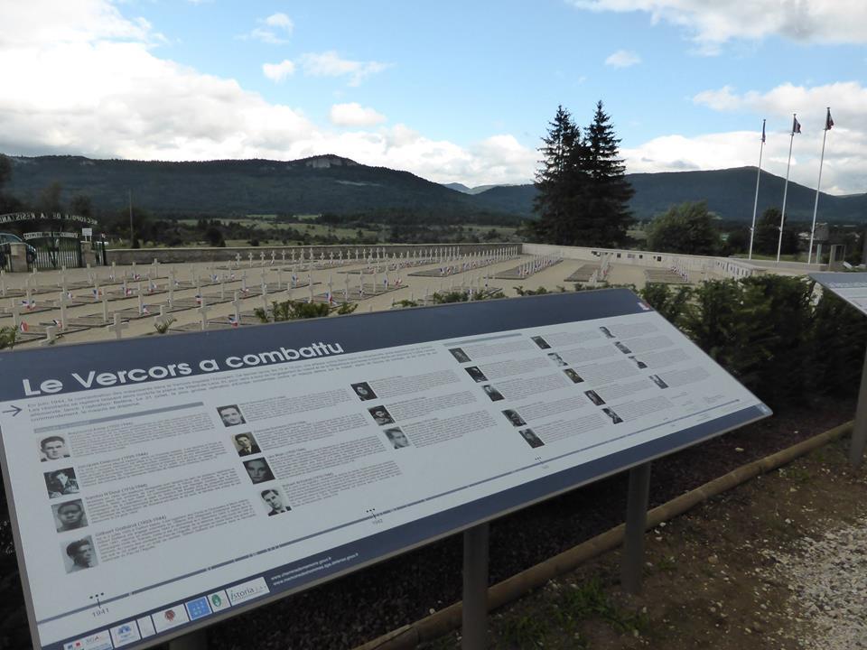
The Vassieux necropolis was created by the Vercors Pioneers Association. An exhibition of portrait panels of Resistance fighters and civilians from the 1940-1945 period can be seen there. This exhibition makes present and concrete the meaning of these high places of commemoration.
You will find here the document which includes the panels of this presentation (les panneaux de cette présentation).
Ambel
It was under the cover of a forestry operation that the first resistance fighters were welcomed at the end of December 1942 on the Ambel plateau in the Drôme. The forest belonged to Victor Huillier, one of the precursors of the Franc-Tireur movement in Villard-de-Lans. After obtaining his agreement, a whole chain of solidarity was set up under the direction of Pierre Brunet, who was himself hired as deputy director in charge of material matters: food and lodging for the staff, accounting and, above all, recruitment. In February 1943, the workforce reached 85 men.
Ambel is often considered to be “the first maquis in France”.
Author: Julien Guillon
The Royans, the Gervanne and the Isère Valley
This area forms the western slope of the Vercors massif. To the north, Le Royans is a hilly region, with livestock farming and walnut growing. Access to the massif is relatively easy via roads cut into the rock at the end of the 19th century.
To the south, the Gervanne is an area of rugged hills at the foot of the plateaus bordering the Vercors massif. This “small country” is essentially turned towards Crest.
These two areas, from north to south, are bordered by the river Isère, which, coming from the Voreppe Cluse, flows into the Rhône, a few kilometres from Valence.
Three events of different natures concern these areas:
- the mobilisation of the Vercors, on 9 June 1944 ;
- the German attack of 21 July 1944 on four directions: Saint-Nizier/Villard-de-Lans, the Pas de la falaise orientale, the Vercors drômois and Vassieux-en-Vercors;
- the dispersal order given on 23 July 1944 by F. Huet (Hervieux) to all the fighters in the Vercors.
During the German sweep of the massif, some of these fighters, sometimes from the Drôme, decided to disperse in an attempt to escape the enemy’s cordon along the Isère, at the outlets of the massif, individually or in small groups. Many were captured and executed. Civilian hostages were massacred.
These events justify the erection of numerous memorial sites, some of which recall the climb to the Vercors following the mobilisation order of 9 June 1944.
Authors: Julien Guillon and Guy Giraud
Romans-sur-Isère – Bourg-de-Péage
On June 9th 1944, it is the mobilization: the civil companies, sedentary, as well as the volunteers, of which Romanais and Péageois, join the Vercors.
On 17 July, the commune of Pont-en-Royans was violently bombed.
The fighting in June and July, followed by the dispersal order, caused many victims.
Author: Guy Giraud
The Diois
The Diois is a region of the Drôme valley located in the southern foothills of the Vercors massif, stretching from the vicinity of Saillans in the west to the Rousset Passes in the north, and to the Menée, Grimone, and Cabre Passes on the eastern flank. The Diois is dominated by the Glandasse mountain, the southern barrier of the Vercors. The most common access is from the Rhone valley to the west from Valence and Crest, and to a lesser extent via the Menée pass towards Grenoble. The junction between the Vercors massif, apart from the mule tracks, is via the Rousset pass.
The locations of the memorial sites in the area from Die to the Col de Rousset to Vassieux-en-Vercors are the result of the militia incursion from 17 to 24 April 1944 and the fighting that took place in Vassieux from 21 to 24 July 1944.
This fighting was linked to the existence of the Taille-crayon landing field set up in anticipation of the arrival of Allied airborne troops. The Pons battalion of the Drôme was given the mission of covering the field from Crest to Die. The Resistance fighters of Vassieux and those locking the accesses to the area from the passes of Rousset, Font-Payanne, La-Chau and Proncel will try to oppose the occupation of Vassieux by the Luftwaffe airborne special forces near Taille-crayon. From 21 to 25 July, the Germans committed numerous massacres of combatants and civilians.
Author: Guy Giraud
From the Trièves to the Grenoble area
The ridge of the eastern flank, fifty kilometres long, has several peaks exceeding 2,000 metres in altitude.
The Trièves, to the east, is a low undulating plateau between the highest peaks of the Vercors and the Drac gorges. It is the most isolated region from the rest of the massif.
From November 1943 to May 1944, the sector stretching from the crests of the eastern cliff to the Drac was subjected to particularly well-targeted Italian and German raids.
From 21 July 1944, the Germans attacked the Vercors resistance in four directions, starting at the Drac towards the Pas de la falaise.
At the same time, they cordoned off the outer perimeter of the massif to prevent the escape of fighters to the Drôme or Isère.
To the east, they watched over the steep slopes of the cliff which, from the Pas, led to the Drac and, beyond, to the Trièves and the Oisans.
In the course of this unequal struggle, maquisards, alone or in teams of a few men, were intercepted and shot. Civilians were sometimes taken hostage and shot or deported. However, some fighters managed to get through the German checkpoints.
These events explain the large number of memorial sites between the cliff line and the Drac.
Authors: Guy Giraud and Julien Guillon
The Trièves
It is a multiform resistance that characterizes the Trièves, Sector IV of the Secret Army of Isère, benefiting from many complicities.
It is a tradition of welcome and refuge.
In Prélenfrey-du-Gua, the Guidi family, Protestants, opened in 1936 a preventorium called “Les Tilleuls”. From 1940-1941, the establishment took in Jewish children from persecuted families [1], most of whom were sent by the Œuvre de Secours aux Enfants (OSE). Other families took in Jewish children and a few refractory ones sent by Henri Bertrand, alias X2[2], or the Girard-Clot family from Grenoble [3]. They were then placed individually on farms or in forestry operations.
It was also the crucible for the reconstitution of military units.
After the disbandment of the armistice army in the vicinity of Monestier-de-Clermont, about forty men from the 6th BCA trained intensively: they followed the Manuel d’entraînement du Fantassin (infantryman’s training manual) of General Laffargue, commander of the Grenoble military subdivision, like a bible [4].
From 1943 onwards and the introduction of the STO, camps were to be set up.
In March 1943, Jacques Molé, who had joined the Resistance in Lyon, founded the “Clan Notre-Dame-des-Maquis” group, which aimed to bring together scouts called up for the STO. He went to the Trièves [5]. 5] Appointed head of the A.S. sector, he travelled around the area to set up camps to welcome draft dodgers [6].
At the beginning of August 1943, in Tréminis, Jean-Claude Rozan (Lanval), set up a camp that included about thirty individuals.
In September 1943, a camp was set up in La Sagne, on the initiative of two theology students from the University of Montpellier, which was dissolved on 19 October 1943 by the German army.
In October 1943, the F.T.P. itinerant detachment “Chant du départ” settled in Esparron. Headed by Marcel Dufour, it did not come into contact with the other groups and operated quite independently [7].
During the harsh winter of 1943-1944, camps came to the Trièves to find a less harsh climate and more satisfactory supply possibilities. The C.2, which came from the Carette clearing, south of Corrençon-en-Vercors, settled on the first foothills of the massif and was supplied by Potin from Sector IV [8].
The places of memory reflect, today, the character of a multiform resistance.
Author: Julien Guillon
Sources and references :
1] The inhabitants of Prélenfrey saved the 51 Jews, including 20 children, who had hidden there between 1940 and 1944. Hélène, Georges and André Guidi, as well as the nurse Annie Wahl, received the distinction of “Righteous Among the Nations”. The whole village was also honoured with this distinction.
2] Archives Départementales de l’Isère, 57J50/1, Testimony of Henri Bertrand collected by Suzanne Silvestre on 20 November 1967, 8 pages.
3] A.D. Isère, 57J50/1. Testimony of Miss Girard-Clot taken by Suzanne Silvestre on 17 October 1966, 2 pages.
4] A.D. Isère, 57J50/1. Testimony of Gustave Lombart taken by Suzanne Silvestre on 19 December 1977, 6 pages.
5] Duclos (J-C.) (Under the direction of.), 1939, 1945. L’Isère en Résistance, M.R.D.I., Grenoble, 2005, 194 pages.
6] Duclos (J-C.) (Under the direction of.), 1939, 1945. L’Isère en Résistance, M.R.D.I., Grenoble, 2005, 194 pages.
7] Billat (P.), Levés à l’aube de la Résistance dauphinoise, Sassenage: Imprimeurs réunis, 1978, 218 pages.
8] A.D. Isère, 57J50/1, Testimony of André Genot collected by Suzanne Silvestre on 28 April 1975, 7 pages.
From the Pas to the Drac Valley
In parallel and in relation to the Montagnards Project, the sectors of the piedmont were assigned two major roles. The first was to increase surveillance [1] of enemy movements, and the second was to provide a first line of defence against access to the Vercors massif. Indeed, the passes and cols could be used by troops not necessarily trained and experienced in mountain warfare to access the massif, despite the natural defences.
With this in mind, the groups formed in the Trièves by soldiers of the 6th B.C.A., who had passed over to the O.R.A., were trained to “[…] take or defend a rocky outcrop [2]”, but above all to “[…] harass from above and below the access to the Vercors passes considered accessible [3]”, while the civilian Brisac company was to be immediately mobilised for the defence of St. Nizier-du-Moucherotte.
In July and August 1944, during the dispersal, these accesses were guarded. A few fighters were shot as they tried to leave the massif.
The places of memory that mark out this space are in correlation with the diversity of the stakes.
Author: Julien Guillon
References :
[1] [2] and [3] Archives Départementales de l’Isère – 57J50/1
The Grenoble agglomeration and the Quatre-Montagnes
Two major events can be linked to the memory markers:
During the Second World War, the cliffs and their outlets to the Grenoble conurbation were still in “open country”. From 1943 onwards, when the occupying power emptied its jails, it only took a few kilometres to carry out summary executions in remote and discreet locations.
During the dispersal, from 23 July 1944, the outlets of Saint-Nizier-du-Moucherotte and Engins were watched by German troops. Some fighters were killed during their exfiltration attempt, including Jean Prévost and his companions.
Author: Julien Guillon